 (2).png)
 2 months ago
83
2 months ago
83
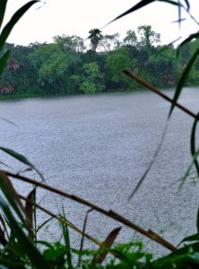 Heavy rain falls along a resaca at The University of Texas Rio Grande Valley Brownsville campus on Wednesday, June 19, 2024, as rain bands from Tropical Storm Alberto cross over South Texas. (Miguel Roberts/The Brownsville Herald)
The days between June 18-24 served as a welcome break from the hot, humid, boring weather that made itself at home in the Rio Grande Valley with a vengeance barely a week into May.
Parched lawns, gardens and farmland turned green again thanks to buckets of beneficial rainfall compliments of Tropical Storm Alberto and its post-tropical-cyclone remnants, which formed in the Bay of Campeche before sliding westward into Mexico well south of the Valley, noted Barry Goldsmith, warning coordination meteorologist with the National Weather Service Brownsville-RGV station.
He said the rain also caused “significant to locally severe” beach erosion on barrier islands — including South Padre Island — thanks to water surging higher than 3 feet above predicted tides on June 19-20.
Despite high hopes, Alberto and its aftermath did not do much for critically low water levels and Amistad and Falcon reservoirs.
“Falcon Reservoir levels ‘came off the mat’ of historically low values, but remained very, very low,” Goldsmith wrote in a NWS update late Monday. “(Water) rises from the weekend of June 14 only moved from 9.25 percent to 10.7 percent of total capacity this afternoon. Additional slow rises are expected for several more days.”
Amistad, about 166 miles northwest of Laredo as the crow flies, missed out on the rain completely and remains at historic low levels, he said, adding that time will tell how much water runs into Mexico’s El Cuchillo and Marte Gomez reservoirs, along the Rio San Juan well south of Rio Grande City. As of Monday morning, Marte Gomez had risen from 32% to 38% of total capacity, while El Cuchillo had jumped from 31% to 75%, Goldsmith said.
“This was likely due to impressive inflows from rainfall that exceeded 25 (inches) in places near Monterrey, with additional heavy rainfall in eastern/northeastern Mexico over the weekend,” he said.
The Valley saw less rain June 19-20 compared to the Texas Coastal Bend and across central Tamaulipas, Mexico, through southern Nuevo Leon, Mexico, and on June 22-23 from central Tamaulipas through southern Nuevo Leon, Goldsmith said. As a result, the Valley was spared widespread flooding, which had it happened would’ve aligned very closely with the calendar dates of the “Great June Flood of 2018,’ he noted.
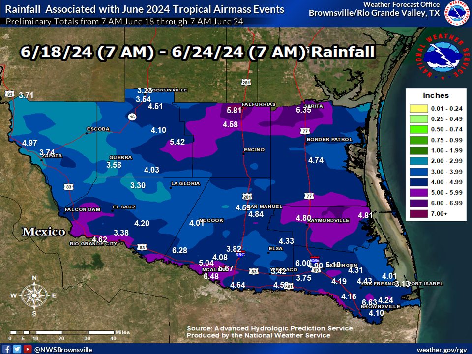 This graphic shows rainfall across the Valley from Tropical Storm Alberto on June 19, 2024, and its post-tropical-cyclone remnants. (Courtesy: National Weather Service/NWS)
The NWS also on Monday released its estimated rain totals for the Valley for the period between 7 a.m. June 18 and 7 a.m. June 24. The highest amounts fell in isolated portions of northern Willacy, Kenedy and Brooks counties, where at least 6 inches of rain fell. Other areas received at least 5 inches, including Raymondville, Rio Grande City, McAllen and localized spots in Cameron County, though most of the Valley got between 3 and 5 inches.
Meanwhile, as of mid-day Tuesday, the National Hurricane Center was watching a tropical wave located over the southeastern Caribbean Sea, producing “disorganized showers and thunderstorms as it moves quickly westward at around 25 mph.”
The NHC said environmental conditions “could support some gradual development once the wave reaches the western Caribbean Sea late this week.”
Further development is possible over the southwestern Gulf of Mexico (Bay of Campeche) over the weekend, according to the NHC, which gave the new disturbance only a 10% chance of becoming a tropical cyclone within 48 hours, and only a 20% chance of turning into one within seven days.
The post Better than nothing: Reservoir levels benefit slightly from Alberto appeared first on MyRGV.com.


 English (US)